Carte du nord de Tahiti de la Pointe Vénus au port de Taaone (1791)

Cliquer sur l’image pour l’agrandir
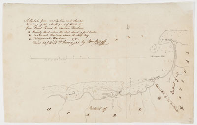
Titre : Series 50.06: ‘A Sketch from recollection and Anchor Bearings of the North part of Otaheite from Point Venus to Taowne Harbour’, ca 1791.
Collection : Sir Joseph Banks papers
Auteur : William Bligh (1754-1817)
Date : 1791
Sujet : Carte des côtes tahitiennes de la Pointe Vénus à la passe du Taaone, districts de Matavai et Oparre. Texte manuscrit : A sketch from recollection and anchor bearings of the north part of Otaheite from Point Venus to Taaone harbour.
A Bounty Rock, where the ship struck, 3 feet water.
B Toahroah harbour where the ship lay.
C Tettyoorrah harbour.
First explored survey by W. Bligh. Ce plan est mentionné par Bligh dans une lettre datée du 17 juillet 1791.
Type : Carte manuscrite
Droits : Domaine public
Identifiant : FL3188134 – Série 50.06
Source : State Library of New South Wales
Lien : http://www.sl.nsw.gov.au/banks/section-09/series-50/50-06-a-sketch-from-recollection-and-anchor
Categories: 1790 - 1799, Anglais, Cartographie, Manuscrits & tapuscrits, Société, State Library New South Wales, Tahiti
Laisser un commentaire